History of Porter County, 1912County history published by The Lewis Publishing Company . . . .
Source Citation:
The Lewis Publishing Company. 1912.
History of Porter County, Indiana: A
Narrative Account of its Historical Progress, its People and its Principal
Interests.
Volume I. Chicago, Illinois: The Lewis Publishing Company. 357 p.
HISTORY OF PORTER COUNTY
97
CHAPTER VII
TOWNSHIP HISTORY
FIRST TOWNSHIPS - CHANGES IN
BOUNDARIES - NEW TOWNSHIPS CREATED AND OLD ONES DISORGANIZED - BOONE TOWNSHIP -
SETTLEMENT OF - FIRST ELECTION - EARLY AND MODERN SCHOOLS - HEBRON - SETTLEMENT
AND INCORPORATION OF - RAILROADS - HIGHWAYS - CENTER TOWNSHIP - PHYSICAL
FEATURES- CHIQUA'S TOWN - FIRST SETTLERS - ELECTIONS - EARLY EVENTS - SCHOOLS -
TRANSPORTATION FACILITIES - HIGHWAYS - JACKSON TOWNSHIP - OF GLACIAL ORIGIN
-NAME - FIRST SETTLERS - EARLY ELECTIONS - MILLS - VILLAGES - SCHOOLS -
RAILROADS - POPULATION - LIBERTY TOWNSHIP - LAND TROUBLES - SETTLEMENTS - DEATH
OF MRS. HUGHART - EARLY WEDDING FESTIVITIES - ELECTIONS - HIGHWAYS - FIRST
STEAMBOAT - RAILROADS AND VILLAGES - MORGAN TOWNSHIP - ORGANIZED, 1843 - FIRST
SETTLERS - INDIAN TRADITION - GAME AND BEE TREES - PRAIRIE FIRES - AGNEW'S
TRAGIC DEATH - TASSINONG - MBLDEN - LIBERTY VIEW - SCHOOLS - RAILROADS AND
HIGHWAYS - CENSUS.
In the chapter relating to Settlement and Organization, will be found the order
of the board of county commissioners, issued in April, 1836, dividing the county
into the ten townships of Lake, Jackson, Washington, Pleasant, Boone, Center,
Liberty, Waverly, Portage and Union. In the years following numerous changes
were made in the boundary lines; some of the original townships have
disappeared; new ones were created and again disorganized, until 1880, when the
present twelve townships were established.
127
At the May meeting of the board in 1836, only one month after the erection of
the first townships, the northern boundary of Pleasant township "was extended
west to the center of the great marsh dividing Horse and Morgan prairies," and
the western boundary extended from that point "south with the center of the
marsh to the Kankakee river." The eastern boundary of Boone township was fixed
"at the west side of said marsh." In June, 1836, the citizens of Lake and
Waverly townships presented a petition to the board asking that the two
townships be united. The commissioners granted the petition, Lake and Waverly
disappeared from the map of Porter county, and the territory comprising them was
erected into the township of Westchester.
The following year the west half of section 29, township 35, range 5, was taken
from Washington and attached to Center. In March 1839, the west half of sections
17 and 20 in the same township and range was likewise taken from Washington and
added to Center, but in May 1840, all this territory was restored to Washington
township.
By an order of the board in March, 1838, "all the territory of Porter county
west of the marsh dividing Morgan and Horse prairies, and between the line
dividing townships 33 and 34 and the line dividing townships 34 and 35" was
organized as Fish Lake township. The name of this township was changed to Porter
in June, 1841. In March, 1841, township 37, and fractional township 38, in range
5, were taken from Westchester township and erected into a new township called
Berry. This arrangement did not please the people of Westchester, and at the
June term they presented a petition to the board setting forth that the division
of the township was "injudicious and uncalled for, and is inconvenient for the
citizens of your township generally," and asking that the order be revoked. This
petition was signed by Enos Thomas, W. P. Ward, Guffin Hulbert, William Knapp,
John Millard ,William Coleman, David Price, William P. Jacobs, Brazilla Millard,
Rufus Pierce, Joseph Clark, Daniel Hulbert, Henry Hageman, William Thomas, John
Thomas, Allen Blair, James Thomas, Samuel Wheeler, Thomas Frazier, Vincent
Thomas and Edmund Tratebas. After hearing the petition, the board
128
ordered "That the above petition be granted, and that the order for the division
of Westchester township, and for the establishment of Berry township, made at
the March term of this board, 1841, be rescinded, and that the elections
hereafter be held at former place."
It was at that term that the name of Fish Lake township was changed to Porter,
and the boundary line between Pleasant, Boone and Porter was fixed as follows:
"Commencing at the northwest corner of section 2, township 34, range 6; thence
south to the southwest corner of section 14, township 33, range 6; thence west
one mile, and thence south to the Kankakee river."
Several changes were made at the February term in 1847. Section 1 to 6,
inclusive, in township 36, all of township 37, and fractional township 38, range
5, were taken to form a new township to be known as Calumet. This included all
of the present township of Pine, a strip two miles wide off the east side of
Westchester, and two square miles in the northern part of Jackson. At the same
time Westchester township was defined as including all of township 37, range 6,
and the east half of township 37, range 7. Liberty township was given its
present form and dimensions, except that sections 1, 2, 3 and 4, township 36,
range 6, then belonged to that township. These four sections were given to
Westchester in December, 1852. In June, 1847, Westchester township was reduced
in size, "all that part lying west of the line dividing ranges 6 and 7, and
sections 29 and 32, township 37, range 6," being attached to Portage township.
A petition was presented to the board of commissioners in August, 1848, asking
for the erection of a new township to be composed of territory taken from
Jackson, Liberty, Westchester and Pine, but a determined opposition developed
and the board refused to grant the petition and issue an order for the formation
of the township. No more changes were made until in February, 1850, when
sections 29, 30, 31 and 32, township 37, range 6, and sections 25, 26, 27, 34,
35 and 36, township 37, range 7, were added to the township of Portage. These
sections constitute a strip two miles in width across the southern part of the
present
129
township. At the same session of the board Essex township was created by taking
a strip one and a half miles wide off the east side of Morgan township. Essex
was so named for the vessel commanded by Commodore David Porter in the War of
1812. As originally created it contained but nine square miles, being a mile and
a half wide from east to west and six miles long from north to south.
Subsequently the western boundary was extended to a line marking the center of
township 34, thus giving it an area of eighteen square miles.
Pine township was established in June, 1852, when Westchester was divided "by a
line commencing at the southwest corner of section 5, township 36, range 5,
thence running north on the section line to Lake Michigan," all the territory
east of that line being attached to Pine township and that west of it remaining
as Westchester.
Sections 23, 26 and 35, township 36, range 6, were added to Porter township by
order of the board in March, 1855, and no further alterations were made in
township lines until in March, 1864, when for some reason a strip a quarter of a
mile wide and a mile long - the east half of the east half of section 30,
township 35, range 5 - was taken from Center and added to Washington. This strip
was restored to Center in December, 1868. In September, 1864, sections 3 and 4,
township 36, range 5, were taken from Pine and added to Jackson. In 1880 a
petition signed by sixty-seven citizens of Essex and Morgan townships was
presented to the board asking for the consolidation of the two townships. Essex
was accordingly abolished, the territory attached to Morgan, and since that time
there has been no change in township lines. The twelve townships of Porter
county are Boone, Center, Jackson, Liberty, Morgan, Pine, Pleasant, Portage,
Porter, Union, Washington and Westchester.
BOONE TOWNSHIP
Boone township,
situated in the southwest corner of the county, was created by the county
commissioners at their first meeting in April, 1836, though the boundary lines
were changed several times before the
130
township assumed its present form. It is bounded on the north by Porter
township; on the east by Pleasant; south by the Kankakee river, which separates
it from Jasper county, and on the west by Lake county. Its area is approximately
thirty-six square miles. The surface slopes gently toward the Kankakee river on
the south. At first, the township was a fine prairie, with fine groves of timber
scattered here and there, soft maple, elm, hickory and black walnut being the
principal varieties of forest trees. Some of the land lies in the Kankakee swamp
region, but by scientific and systematic ditching much of this land has been
reclaimed, and practically the entire township is under cultivation. There are
no mineral deposits worthy of mention, hence agriculture is the principal
occupation of the inhabitants. The soil is above the aveage in fertility and
large crops of hay, cereals, potatoes and other vegetables are raised.
The first permanent settlers in the township were Jesse Johnston, Isaac Cornell
and Simeon Bryant, all of whom came in the year 1836 in the order named. The
next year Thomas Dinwiddie, Absalom Morris, Orris Jewett, Solomon and James
Dilley brought their families and settled near those who had come the preceding
year. Other early settlers were John Prin, Thomas Johnson, Jennings Johnson,
Frederick Wineinger, William Bissell, George Eisley, William Johnson, A. D.
McCord, John Moore, John W. Dinwiddie, John Oliver, Amos Andrews, Joseph Laird,
T. C. Sweeney, E. W. Palmer and a man named Bricer, all of whom had located in
the township by the close of the year 1837.
When the board of county commissioners established the first townships, an
election was ordered in Boone for the last day of April for one justice of the
peace. This election was held at the house of Jesse Johnston and seven votes
were cast, of which Mr. Johnston received six and Aschel Neal, one. Another
election was held at the same place on September 24, 1836, for one justice of
the peace, when John W. Dinwiddie was elected without opposition, receiving the
seven votes cast. At this election Jesse Johnston was inspector; Joseph Laird
and William Bissel were judges; John W. Dinwiddie and Isaac Cornell, clerks.
131
Besides these five members of the election board, the only two voters were A. D.
McCord and John Moore, though there were then in the township twenty men who
were entitled to vote.
The first birth was that of Margaret Bryant - April 16, 1837. Harriet Dinwiddie,
the youngest child in a large family, died the same year and was the first death
in the township. The first marriage is believed to be that of James Dilley and
Sarah Richards, though the date cannot be ascertained. Orris Jewett, one of the
early settlers above mentioned, was a blacksmith, and for several years his shop
was the only one in Boone township. The few settlers who brought their families
with them felt the need of educational facilities for their children, and in
1837 they erected a log school house of the most primitive pattern in which a
school was taught in the fall of that year, but the name of the teacher seems to
have been forgotten. A Presbyterian church was organized in July, 1838, by a
minister named Hannan, and after a few years the old school house was abandoned
and the church building used for school purposes. In 1840 a second school house
was built about a mile and a half southwest of the present town of Hebron. It
was also a log structure, about 18 by 20 feet in size. The third school house in
the township was built on the northeast corner of section 15, township 33, range
7, in 1842, and Mary Crossman was the first teacher. Two years later the
building was burned. Some of the early teachers were Ellen Hemes, Amos Andrews,
James Turner, Eliza Russell, Sarah Richards, Rhoda Wallace, George Espy and
Alexander Hamilton. Mr. Hamilton afterward studied law and became a prominent
attorney in the city of Chicago. The first frame school house in the township
was located two miles east of Hebron. In May, 1853, a meeting was held for the
purpose of determining whether a special tax for the support of free schools
should be levied. Fourteen votes were cast, ten of which were against the levy
and four in favor of it, so the proposition failed to carry and the old school
system was continued in operation. In 1854, the highest amount received from the
state school fund by any district in the township was $43.00, and the lowest was
$12.62. For the school year of
132
1911-12 there were eight teachers employed in the Hebron high school and five in
the district schools. In the high school M. E. Dinsmore was superintendent;
Elizabeth Patton, principal; and the teachers were R. M. Hamilton, Thomas G.
Scott, Maggie Rex, Neva Nichols, Emma Morgan and Hattie Felton. Outside of the
high school the teachers for the year were: District No. 1 (Malone), Grace Ling;
District No. 2 (Aylesworth), Ruby Wood; District No. 6 (Bryant), Edna Dilley; District No. 7 (Tannehill), Bess Hawbrook; District No. 8 (Frye), Mabel
Wheeler.
At the time the first white men came to Boone township, there were still a
number of Indians living there, and in a few instances they showed a disposition
to make trouble for the settlers, notwithatanding they had ceded their lands to
the United States in 1832. A story is told of how old chief Shaw-ne-quo-ke came
to the cabin of Simeon Bryant one day in 1836 while the "men folks" were absent
and demanded that the white men vacate the Indian "hunting grounds." Taking a
piece of chalk, the old chief drew a rude circle upon the floor, and then
explained in the Indian tongue that all the land within a radius of five miles
belonged to the people of his tribe. As Mrs. Bryant made no move toward giving
up her frontier home, the Indian grew incensed, and seizing a butcher knife
threatened to kill her if she did not leave immediately. The woman's screams
awakened two large dogs that lay asleep in the cabin, and this fortunate
circumstance doubtless saved her life. The dogs attacked the Indian with such
vigor that his designs upon Mrs. Bryant were thwarted, and as soon as he could
get away from the ferocious animals he beat a hasty retreat to the Indian
encampment. A few years later the red men were removed to their reservations
west of the Mississippi river, leaving the white men in undisputed possession of
their homes. For a quarter of a century after the first settlement, the
population Increased but slowly, with the exception of a tide of immigration in
the latter '40s. Dr. Griffin, who settled at Walnut Grove in 1838,was probably
the first physician in the township. When the railroad came through
133
in 1863 a large number of people came with it, most of them settling in the
vicinity of Hebron. Since then the growth has been gradual but sub- stantial.
The town of Hebron had its beginning in 1844, when John Alyea laid out three
lots of one acre each at the cross-roads a mile east of the Lake county line,
where the Presbyterians had erected a small church some four of five years
before. The next year a man named Bagley built a log house there - the first
dwelling in Hebron. That year Mr. Blain, the Presbyterian minister, succeeded in
having a postoffice located at the "Corners," as the place had been known up to
that time, and the name of Hebron was given to the postoffice, Mr. Blain being
appointed the first postmaster. In 1846 Samuel Alyea built the second house and
put in a small stock of goods. His store was about forty yards from the
cross-roads, but a year or two later he formed a partnership with E. W. Palmer
and a new store was erected near the junction of the roads. An addition was made
to the town in 1849 by Mr. James, who laid out several half-acre lots south and
east of the cross-roads. West of this addition the Siglar brothers laid out a
tier of lots in section 15 in 1852. In 1864, when the railroad was completed
through the town, the Siglars also laid out a considerable addition in sections
10, 11 and 15. Three years later, Patrick's addition was laid out in the
southeast quarter of section 10. The first brick building in Hebron was the
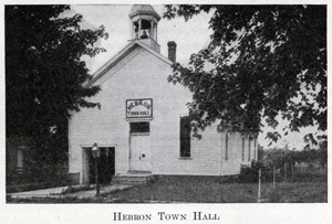
residence of Daniel Siglar, which was built in 1867. Sweeney & Son built the
first brick business building in 1875. It was two stories in height, the upper
story being used as the town hall. The first hotel was opened by Samuel McCune
in 1849. After him the house was successively conducted by Tazwell Rice, Harvey
Allen and John Skelton. In 1865 the Pratt House was opened by Bur rell Pratt.
About two years later he sold the house to another Mr. Pratt - no relation of
his - who kept it for two years. The house then changed hands several times,
being conducted by John Brey, John Gordon, Harvey Allen and John Siglar, the
last named taking charge in 1879, when he changed the name to the Bates House.
Henry Smith started a hotel near the railroad station in 1866. He was succeeded
by a Mr. Winslow,
134
and when he went out of business the house was purchased by a man named Poole,
who converted it into a dwelling. The Central House, built in 1878 by John
Skelton, was operated as a hotel for over two years, when it was also turned
into a residence. Bumstead's County Directory for 1911-12 gives but one hotel in
Hebron - the Commercial, kept by Otto Wharton. A newspaper called the Free
Press was started at Hebron in September, 1878, by H. R. Gregory. The next
year
the name was changed to the Local News, and in 1880 the publication
office was removed to Lowell, Lake county. Dr. John K. Blackstone was the first
physician to locate in the town. He was soon followed by Dr. S. R. Pratt. Other
early physicians were Andrew J. Sparks and Dr. Sales. In July, 1838, Bethlehem
church of Associate Reform Presbyterians was organized by a minister named
Hannan. The Methodists had been holding meetings for a year or more previous to
that date, and a congregation was regularly organized by Rev. Jacob Colclasier
in the latter part of 1837. The Old Style Presbyterians organized in 1860; the
Union Mission Church in 1877; a Congregational church in 1882, and a Chris-
135
tian church some years later. (For a more detailed account of these churches see
the chapter on Religious History.)
The first attempt to incorporate the town of Hebron was in the year 1874. This
was followed by two other unsuccessful efforts, and it was not until 1886 that
the town was incorporated. On August 1, 1886, a census was taken by Aaron W.
Fehrman, and a petition signed by seventy-four residents was filed with the
county commissioners praying for incorporation. With the petition was also filed
a map of the proposed town, embracing 186.08 acres in the southeast quarter of
section 10, the southwest quarter of section 11, the northwest quarter of
section 14, and the northeast quarter of section 15, all in township 33, range
7. The census report showed a population of 663 within the corporate limits as
defined by the map. At the September term the board of commissioners granted the
petition, subject to a vote of the people, and ordered an election to be held
for that purpose on Saturday, October 2, 1886. At that election a majority of
the electors expressed themselves as in favor of the project, and Hebron became
an incorporated town. Since that time the growth of Hebron has been gradual, the
United States census reports showing a population of 689 in 1890; 794 in 1900,
and 821 in 1910. A number of the leading secret orders are represented in the
town, to wit: Hebron Lodge, Free and Accepted Masons; Spencer-Baker Chapter,
Order of the Eastern Star; Hebron Tent, Knights of the Maccabees; Court Hebron,
Independent Order of Foresters; Hebron Camp, Modern Woodmen of America; Hebron
Lodge, Knights of Pythias; Hebron Temple of the Pythian Sisters; Shiloh Camp,
Sons of Veterans, and Walters Post, Grand Army of the Republic. A lodge of the
Independent Order of Odd Fellows was organized there at a comparatively early
date, but it was allowed to lapse, and the records concerning it have apparently
been lost. According to Bumstead's County Directory, already referred to, the
town government for 1911-12 was composed of A: W. Blanchard, president; Roy
Rathburn, clerk; O. E. Bagley, treasurer; I. V. Fry and B. F. Nichols, trustees,
and E. F. Phillips, marshal. Among the business concerns are the Citizens' Bank,
the Hebron Tele-
136
phone Company, a butter and cheese factory, the Hebron Lumber Company, the
implement house of A. V. Phillips, the hardware store of W. F. Morgan, four
general stores, the Commercial Hotel and the Hebron News. There are also
livery stables, jewelry and drug stores, a bakery, millinery stores, a
confectioner, and the town has its quota of physicians, dentists, etc. The
Hebron postoffice is authorized to issue international money orders, and three
rural delivery routes supply mail daily surrounding agricultural districts.
Boone township is well supplied with transportation facilities by the Pittsburg,
Cincinnati, Chicago & St. Louis Railroad Company, which operates a double track
line through the township, entering on the east two miles south of the northern
boundary and running due west to Hebron, where it turns northwest and crosses
the west line of the county one mile north of Hebron. Aylesworth is a flag
station on this road, four miles east of Hebron, and with the exception of a
small portion of the southwest corner, no part of the township is more than
three miles from the railroad. There are over twenty miles of macadamized road
in the township, most of the lines leading to Hebron, so that the farmers have
splendid opportunities for marketing their produce.
CENTER TOWNSHIP
This township, one
of the original ten organized on April 12, 1836, was so named because it
occupies the central portion of the county. Several changes have been made in
the original boundaries, and at the present time the dimensions of the township
are five miles east and west and six miles north and south, giving it an area of
thirty square miles. It is bounded on the north by the township of Liberty; east
by Washington; south by Morgan and Porter, and west by Union. Being situated
upon the high ridge or moraine that separates the valley of the Calumet river on
the north from the valley of the Kankakee on the south, the surface is
undulating and the soil is generally of clay, or of clay and sand alternately.
Marl beds and peat bogs are found in the Salt
137
creek valley, and iron ore exists in small quantities near the city of
Valparaiso, but none of these deposits has been developed. Flint Lake lies near
the northwest corner, Bull's Eye or Round Lake is just west of the Chesterton
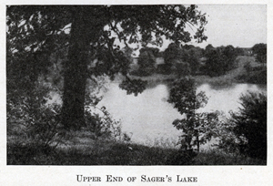
road, about two miles northwest of Valparaiso, and Sager's Lake is situated in
the southeastern suburbs of that city. When the fist white men came to the
township, they found considerable forests of hard and soft maple, black and
white walnut, hickory, elm, basswood and several varieties of oak, but most of
the native timber has been cleared off
to make way for the fields of the
husbandmen. Agriculture is the chief occupation of the inhabitants, and the
crops grown are of the same general character as those of the other townships in
the central and southern parts of the county.
During the Indian occupancy of the region now comprising Porter county, there
was in the western part of Laporte county an opening between two tracts of
timbered land. To this opening the early French traders gave the name of La
Porte - "The Gate." Over the prairie thus named ran the trail leading from the
Kankakee river in Illinois to the
138
Great Lakes. Later the English conferred upon it the name Door Prairie, and the
little town which grew up there took the name of Door Village. Some of the early
settlers, as they worked their way westward into Porter county, passed through
the "Door" and established their frontier homes, some of them locating in Center
township. At that time there was a small Indian village of some dozen lodges
located on the west side of section 19, township 35, range 5, between the
present Laporte pike and the Grand Trunk railway, less than one mile east of
Valparaiso. This village was known as Chiqua's Town, from an old Pottawatomie
Indian bearing that name. Chiqua had at one time been an influential chief in
his tribe, but a few years before the treaty of 1832 his love for "fire-water"
had led him to indulge in a protracted drunk, and while intoxicated his hut was
destroyed by fire, his squaw losing her life in the flames. For his dissolute
habits he was deprived of his chieftainship, but a few of his friends remained
true to him, and these, seceding from the main body of the tribe, established
the village under Chiqua's leadership.
Some time in the late summer or early fall of 1833 Seth Hull located a claim on
or near the site of this village, thereby becoming the first white settler in
Center township. He remained but a short time, selling his claim to J. S.
Wallace and going on farther west. Thomas A. E. Campbell took a claim east of
Hull's, near the Washington township line, and built a cabin, but soon afterward
went back to New York state, where he remained until 1835. Some of the settlers
who came in the year 1834 were Benjamin McCarty, who settled on section 22 on
the Joliet road; Ruel Starr, who located his claim in the eastern part of the
township; Philander A. Paine, who built his cabin on the northeast quarter of
section 23, and his father, who located east of the Salt creek bridge on the
Joliet road and began the erection of a sawmill, which was never finished. The
same year a man named Nise settled on the northwest quarter of section 24, about
three-quarters of a mile northeast of the public square in Valparaiso, but soon
afterward sold out to a German by the name of Charles Minnick. In this year came
also J. P. Ballard, who erected the
139
first building within the present city limits of Valparaiso. Among those who
came in 1835 may be mentioned C. A. Ballard, Alanson Finney and Samuel A.
Shigley. The first settled on the northwest quarter of section 25, Mr. Finney
located his claim west of Ruel Starr's, and Mr. Shigley built a sawmill on the
site afterward occupied by William Sager's flour mill, the first sawmill in the
township. When Thomas A. E. Campbell returned to the county in 1835, instead of
perfecting title to his claim in the eastern part of Center township, he bought
out Philander A. Paine and settled on the northeast quarter of section 23, where
he passed the remainder of his life.
In dividing the county into civil townships, the board of county commissioners
ordered an election to be held on the last day of April, 1836, for justices of
the peace. In Center township the election was held at the house of C. A.
Ballard. Thirteen votes were polled, of which Ruel Starr received nine votes and
was declared elected. His opponents were G. Z. Salyer and John McConnell. At the
May meeting of the board it was decided to give Center township an additional
justice of the peace, and an election was held at the same place on May 28,
1836, when G. Z. Salyer received eight out of fifteen votes. At the presidential
election on November 8, 1836, General Harrison received fifty-nine votes and
Martin Van Buren received forty-five. At the state election in August, 1837,
there were 126 votes cast, of which David Wallace received 101. In 1840 the
total number of votes cast at the presidential election was 287, General
Harrison receiving 149. This increase in the voting strength during the first
five years of the township's history will give the reader some idea of the
growth in population during the same period.
The first birth and the first death in the township are uncertain. The first
marriage was that of Richard Henthorne to Jane Spurlock, May 5, 1836, Rev. Cyrus
Spurlock, who was also county recorder, officiating. About 1838 a man named
Kinsey put up a wool carding mill about a mile and a half south of Valparaiso.
It was operated by water power, the water being conveyed through a large hollow
log to an overshot wheel. Mr. Kinsey also put in a small pair of buhrs for
grinding wheat and
140
corn on certain days. A year or two later a second carding mill was erected by
Jacob Axe on Salt creek, a short distance above Shigley's sawmill. The flour
mill later owned by William Sager was built by William Cheney in 1841. Eleven
years later Mr. Cheney and Truman Freeman built a small flour mill in the
southern part of Valparaiso, though at that time the mill site was outside the
corporate limits of the town. Another pioneer mill was a steam sawmill at Flint
Lake, erected by a man named Allen, though the exact date cannot be learned. It
was supplied with two boilers, each twenty-eight feet long and forty-four.
inches in diameter. In 1863 one of the boilers blew up, the boiler being thrown
some 500 feet and landing in the marsh at the lower end of the lake. The
remaining boiler was subsequently removed to Valparaiso to be used in the paper
mill. The first tan-yard in the township, and probably the first in the county,
was established by a Mr. Hatch just south of Valparaiso in 1843. A steam tannery
was started by a man named Gerber on a lot south of the Pittsburg, Fort Wayne &
Chicago railroad about a year before the beginning of the Civil war. The entire
plant wm destroyed by fire in 1874, and since that date there has been no
tanning done in the city.
When the corner-stone of the court-house was laid in October, 1883, Aaron Parks
was township trustee; Temple Windle, John Dunning and Morris Robinson, justices
of the peace, and David C. Herr, assessor. These officers were elected in April,
1882, before the spring elections were abolished by law. At that time there were
eight school districts in the township outside of the city of Valparaiso. In the
school year of 1911-12 there were six districts in the township, the schools
being taught by the following teachers : District No. 1 (Flint Lake), Grace
Banta; No. 2 (Cook's Corners), Mabel Laforce; No. 3 (St. Clair), Rebecca
Bartholomew; No. 4 (Clifford), Hazel McNay; No. 6 (Hayes), Stella Bennett; No. 7
(Leonard), Kathryn Anderson. More than three-quarters of a century have elapsed
since the first white man settled in Center township, but there are still left a
few old
141
persons who can remember the conditions, the labors and the amusements of those
early days. Game was abundant and the trusty rifle of the frontiersman was
depended upon to furnish a goodly portion of the family's meat supply. The
log-rolling, the house-raising and the holiday shooting match afforded
opportunities for the settlers to get together, and on such occasion there were
wrestling or boxing matches and other tests of physical strength. The few
Indians who remained in the country were generally peaceful, and there were no
hair-raising experiences of savage raids, accompanied by burning cabins,
murdered women and children, or stolen live stock. Upon the whole the life of
the Center township pioneers was uneventful. Through the spring and summer they
toiled amid their crops: When the wheat was threshed - with the flail or the old
"ground-hog" - it was hauled to Michigan City, where it was rarely sold for more
than fifty cents per bushel.
Now, all is changed. The market is at the farmer's door. The Pittsburg, Fort
Wayne & Chicago, the New York, Chicago & St. Louis, and the Grand Trunk railways
traverse the county, all passing through Valparaiso, and in the township there
are more than forty miles of excellent macadamized highway, most of the roads
centering at the county seat. Where the farmer formerly hauled twenty bushels of
wheat thirty or forty miles to Michigan City, he can now take sixty bushels over
an improved, modern highway a distance of from two to four miles, and in a few
hours that wheat is in the great grain mart of Chicago, where it commands the
highest market price. The log cabin has given way to the brick or frame dwelling
house; the tallow candle has been supplanted by the kerosene lamp, acetylene gas
or the electric light, and the automobile now skims across the country where the
ox-team was wont to plod its weary way. Such has been the march of civilization
and progress in Center township. Including the city of Valparaiso, the
population of the township in 1850 was 1,012; in 1860 it was 2,745; by 1870 it
had increased to 4,159; in ,1880 it was 5,957; in 1890 it was 6,062; in 1900 it
had reached 7,222, and in 1910 it was 7,971.
142
JACKSON TOWNSHIP
Jackson township,
one of the eastern tier, is bounded on the north by the townships of Pine and
Westchester; on the east by Laporte county; on the south by Washington township,
and on the west by Liberty and Westchester. Its greatest extent from north to
south is six miles, and from east to west, five miles. The northern boundary is
somewhat irregular, two sections in the northeast corner having been given to
Pine township when it was organized, and one section in the northwest corner has
been added to the township of Westchester. The township was established by the
first board of county commissioners on April 12, 1836, and with the slight
changes in boundary lines as above noted remains as originally created. The area
of the township is twenty-seven square miles. As Jackson township lies in the
morainic belt, the surface is hilly, and in some places broken. Especially is
this true of sections 13, 14 and 15, where the many bowlders show the glacial
origin of this section of the county. On section 16 there is a small lake, some
five acres in area, the waters of which are quite deep. South of the Cady marsh
in the same section is another small lake. Through the southern part of the
township runs the water-shed which divides the basin of the Great Lakes from the
Mississippi valley. The soil is variable, owing to the rough, hilly surface and
the glacial formation, several kinds of soil often being found in the same
field. As a rule, the township is better adapted to fruit growing and stock
raising than to the regular lilies of agriculture, though in some portions good
crops of wheat, oats and corn are raised without difficulty. Heavy timber
covered the entire surface at the time the first settlers came to the township.
This timber was in the way of the pioneer farmer and much of it was felled and
burned to bring the land under cultivation. After the completion of the Wabash
and Baltimore & Ohio railroads, a great deal of cord wood was shipped to
Chicago. There is still some timber, but enough has been wasted to buy all the
land in the township, had a suitable market been available in the early days.
According to the historical sketch deposited in the corner-stone of
143
the court-house in 1883, the township was named "for and in honor of an old
settler, Lemuel Jackson." This statement has been questioned by old settlers,
who claim that it was named for Andrew Jackson, the hero of New Orleans and
president of the United States at the time Porter county was created. The latter
theory is borne out by the following from the Western Ranger of August
11, 1847: "The strong Federal township in this county is called Jackson. This is
disgraceful. A township in which three-fourths of the people are Federalists and
Abolitionists should never bear the name of the illustrious Jackson! Some of our
friends have suggested that the name be changed to Tom Corwin, and we go for it
distinctly. No name would be more suitable."
Early in the year 1834 Asahel K. Paine selected a claim and built the first
cabin in Jackson, thereby becoming the first settler in the township. The second
settler was John P. Noble, who came in April, 1834, and in June H. E. Woodruff
located in the township. Before the close of the year the colony had been
increased by the addition of Calvin Crawford, Joseph Wright, Johnson Crawford,
Samuel Olinger, Lemuel Jackson, E. Casteel and a few others. A number of
settlers came in 1835, among them William Barnard, Benjamin Malsby and William
Eaton. Pursuant to the order of the board of county commissioners, an election
for justice of the peace was held at the house of Asahel K. Paine on April 30,
and H. E. Woodruff was elected to the office. Lemuel Jackson, who had been
elected associate judge, resigned his position, and on December 24, 1836, a
special election was held at the house of William Eaton to choose his successor.
At that election forty votes were cast, showing the steady tide of immigration
to Jackson township during the preceding two years. Seneca Ball received every
one of the forty votes. In 1837 Jesse McCord arrived in the township and
established a blacksmith shop on section 26, about a mile and a half southwest
of Clear Lake. The first tavern was opened by a man named Page in 1836. It was
located south of Page marsh, which was named for him, was a log structure, and
had in connection a large log stable for the accommodation of the horses ridden
or driven by travelers. George A. Garard says this was the only tavern
144
ever conducted in the township, and that was discontinued on account of a change
in the road which diverted travel to another route. However, a man named
Shinabarger settled on the site where Steamburg afterward grew up and opened a
house of entertainment for travelers late in the year 1836, though he did not
claim to keep a regular tavern. Lemuel Jackson built a sawmill on Coffee creek
about 1835 - the first in the township - and for some years did a good business
in sawing lumber for the settlers. Sawmills were built by Samuel Olinger and
Abraham Hall in 1838. Associated with Hall was a man named Dilley. Farther down
Coffee creek was Casteel's saw and grist mill. Near this mill a man named Enox
started a distillery, but it was burned in 1849 by the bursting of the boiler
and was never rebuilt. Smith & Becker built a grist mill with two run of buhrs
for wheat and one for corn, on Coffee creek in 1856, and twenty-five years later
it was the only mill in the township. The first school was taught in a log cabin
located on section 26, on the farm afterward owned by John P. Noble. The first
regular school house was erected in 1838, about a mile and a half east of the
center of the township. It was a log cabin, 16 by 18 feet in size, equipped with
the customary "Yankee fireplace" and greased paper for windows. Jane Jones was
the first teacher in this house. The second school house was built in 1846. In
1883, when the corner-stone of the court house was laid, there were seven
districts in the township. The historical sketch deposited in the corner-stone
was written by Oliver Stell, who was at that time trustee of the township. He
was born in Warren county, Ohio, December 30, 1816, came with his parents to
Indiana in 1821, and to Jackson township, Porter county, in 1844. In the course
of that sketch he says: "In the year 1882 the acreage of wheat was 2,643; oats,
755; corn, 2,468, and potatoes, 150. The number of pounds of pork raised was
931,400; wool, 4,593, and butter, 36,450. At the election of 1882 there were 263
votes polled; at the election of 1836 there were 42 votes polled, showing an
increase of 221 votes in forty-six years." Several small villages sprang up in
Jackson township as the population grew. Jackson Center received its name from
the township and its
145
central location therein. A postoffice was established there in 1856, with E. H.
Johnson as postmaster. The first store there was opened by J. S. Sanders in
1874. Two years later he sold out to a Mr. Hill, who in turn sold to John
Sackman in 1881. Steamburg was located near the southern boundary, about two
miles west of the Laporte line. When the Baltimore & Ohio railroad was built,
about 1875, a railroad station was established at Coburg, just across the line
in Washington township. The people of Steamburg nearly all moved over to the new
station, and Steamburg ceased to exist. Suman, or Sumanville, is a small station
on the Baltimore & Ohio railroad, about three miles northwest of Coburg. It was
established as a postoffice about the time the railroad was completed, with Col.
I. C. B. Suman as postmaster, from whom it derived its name. A store was started
by a man named Jones when the railroad was built, but not meeting with the
patronage he expected, he gave up the enterprise after a few months. Another
store was started in 1881 and met the same fate. Burdick is the most important
village and the only postoffice in the township, the other offices having been
discontinued upon the introduction of the rural delivery system. It is located
on the Lake Shore & Michigan Southern railroad in the northwestern part of the
township and has a population of about seventy-five. A public school is located
here, the postoffice is authorized to issue money orders, and the village is a
trading and shipping point for the surrounding rural districts.
For the school years 1911-12 there were nine teachers employed in the public
schools. In the township high school at Jackson Center Ida Recktenwall was
principal and Hazel Bundy, assistant. In the district schools the teachers were
as follows: No. 1 (Quakerdom), Louisa Malchow; No. 2 (Carter's), Judith Lindwall;
No. 4 (Taylor school), Ethel Rands; No. 6 (Coburg), Lucy Mander; No. 7 (Bogue),
Alta Herrold; No. 8, (Burdick) , Mary Belger; No. 9 (County Line), Carolyn
Whitlock.
School No. 1, known as the Quaker school, or Quakerdom, takes its name from the
fact that at an early date a number of Friends, or Quakers, as they are commonly
called, settled in that locality and established a
146
church. It was a double hewed-log structure and was used for a number of years
as a "meeting-house." Little can be learned concerning this old Quaker
settlement, as the old settlers are all dead and most of their descendants have
removed to other fields of labor. Some years before the Civil war, the
Methodists purchased the old school house at Jackson Center and enlarged it by
an addition so as to render it available for church purposes. Chancey Moore, one
of the early teachers, was class leader here for several years.
Two lines of railroad cross the township in a northwesterly direction, almost
parallel to each other. The Wabash crosses the eastern boundary of the county
near Clear Lake, runs thence northwest to Morris, and thence west, leaving the
township near the northwest corner. The Baltimore & Ohio enters the township on
the south, two miles west of the Laporte county line and runs northwest,
crossing the western boundary one mile east of Woodville. A third railroad - the
Lake Shore & Michigan Southern - crosses the extreme northern part, through
Burdick. These lines, with the stations of Coburg, Suman, Morris, Burdick and
Woodville within easy reach of all parts of the township afford ample
transportation facilities. There are about twelve miles of macadamized road in
Jackson township. For some time after the organization of the township there was
a gradual increase in the population, but in the last twenty years there has
been a slight decrease. This is due to the same causes that have affected so
many rural communities. Young men leave the farms to seek their fortunes in the
cities, and others, lured by the prospects of cheap lands in the West, have
removed to the newer states beyond the Mississippi. In 1890 the population of
the township was 1,009; in 1900 it was 938, and in 1910 it had fallen to 894.
LIBERTY TOWNSHIP
This township was
created by the board of county commissioners at its first session in April,
1836. It lies in the northern part of the county and is bounded on the north by
Westchester township; east by Jackson;
147
south by Center, and west by Portage. It is exactly five miles square and
contains an area of twenty-five square miles. The surface is generally level,
with some swamp lands in the western and northwestern portions. When drained
this land produces large crops of grain and hay. The soil is a dark loam,
running to clay in places. Long Lake, in the southeast corner, is connected with
Flint lake in Center township by a narrow channel; Coffee creek flows across the
northwestern portion, and Salt creek runs along the western border, or rather
across the southwest corner and thence along the western border. The latter
stream furnishes some water-power, and in one place widens to form a pond of
considerable size. Originally, the land was heavily timbered with oak, hickory,
maple, ash, elm, black walnut, butternut, white wood and some minor varieties,
but very little of the native timber remains, except in the swamp districts
which have not yet been brought under cultivation.
Probably more trouble occurred over the land titles and claims in Liberty
township than in all the rest of Porter county. Through the treaties with the
Pottawatomie Indians, the government granted to certain individual members of
that tribe small reservations, known as "floats," varying in size from a quarter
section to a section, and in some cases even more. These "floats" could be
bought of the Indian or half-breed owners for a trifle, and shrewd speculators
took advantage of the situation to purchase a number of them for the purpose of
selling them to actual settlers at a handsome profit. As the Indians to whom
they had been reserved rarely occupied them, white men located upon them, not
knowing the real state of the title. After the occupant had made some
improvement the speculator would appear upon the scene and demand a price that
was often beyond the means of the settler to pay, or his immediate removal from
the land. In the one case the speculator could receive a price for the land much
greater than he had paid for it, and in the other he became possessed of the
improvements made by the settler without cost to himself. Several petitions were
sent to Washington praying for relief, but the government was slow to act and
the pernicious system went on until it culminated in what is known as the
148
"Snavely war." William Crawford located upon one of these Indian tracts - a
quarter section in the northeast part of the township - but subsequently sold it
to William Snavely. A little later Peter White laid claim to the land and asked
the assistance of the law to dispossess Snavely. Charles G. Merrick, who had
been elected sheriff of the county in 1838, organized a posse, and, pursuant to
the order of the court, went to Snavely's for the purpose of evicting him.
Snavely barricaded himself in his cabin, and he and his sons, well armed, put up
a spirited defense. Unable to gain admittance through the doors or windows, the
sheriff ordered some of his men to climb to the top of the house and tear off
the roof. No sooner had they begun to remove the clapboards than Snavely fired
through the opening and wounded one of the men. This had the tendency to stop
active operations on the part of the sheriff and his men, and Snavely, thinking
he had killed the man, made an attempt to escape. He was overtaken, captured and
taken to the county jail, where he remained until his victim recovered from the
wound, which was only a slight one, when he was released upon payment of a fine
and a promise to relinquish the land. Some years after his death, his heirs
received a portion of the value of the improvements made by Snavely while in
possession.
Trouble also resulted through the methods practiced by speculators at the public
land sale at Laporte in 1835. The "land-sharks" were there with long purses,
anxious to get possession of the most valuable tracts, not for the purpose of
establishing homes upon them and bringing them under cultivation, but merely to
hold them until some actual settler would be forced to buy at a large profit to
the original purchaser. Liberty township, with its heavy growth of timber,
offered special attractions to these men. In order to gain an opportunity to
purchase the lands at a low price they frequently gave a quarter section to
those seeking a home not to bid against them. Then by collusion among themselves
they "bought the lands for a song." Those to whom the quarter sections had been
given as bribe not to bid went upon their lands, built houses and founded homes.
Every improvement of this character created
149
a demand for other lands in the township and gave the speculators an excuse for
advancing prices. As most of the land in the township was owned by the
speculators, settlers sought claims elsewhere, and Liberty was slow in
developing.
Owen Crumpacker is credited with being the first settler in the township. He
came from Union county, Indiana, in June, 1834, and was soon followed by William
Downing and Jerry Todhunter. During the next two years John Dillingham, E. P.
Cole, William Gosset, George Hesing, Asa Zane, Ira Biggs, David Hughart, Solomon
Habanz, John White, Abram Snodgrass, Frederick Wolf, John Sefford, William
Calhoun, Daniel Kesler and a few others located within the present limits of the
township. Three settlements were formed by these pioneers. One known as the
Dillingham settlement was in the eastern part; the Zane settlement near the
center, and the Salt creek settlement in the western portion. Soon after his
arrival in 1836, William Gosset built a saw and grist mill on Salt creek, and
with the first lumber sawed he erected the first frame house in the township. It
was a one-story structure, about 24 by 32 feet in size, and later was used for a
church and school house. Gosset's mill was for years a landmark in that portion
of Porter county. The people of the Zane settlement patronized Elijah Casteel's
mill, which was located on Coffee creek, just across the line in Jackson
township.
The first death was that of William Hughart's wife, and it was due to the
escapades of some drunken Indians. One day, in the fall of 1835, some four or
five Indians visited Joseph Bailly's trading post on the Calumet river, where
they took on a cargo of "fire-water," and then started out to annoy the
settlers. William and David Hughart, who lived together, were absent on a hunt
and the Indians tried to force an entrance to the house. The women, though badly
frightened, managed to bar the door, after which they sought refuge in the loft
of the cabin. After beating the door awhile with their tomahawks, the Indians
left, and none too soon for their scalps, for in a little while the brothers
returned. Mrs. Hughart died not long afterward from the effects of the shock. On
June 14, 1836, William Hughart married Elizabeth Zane,
150
which was the first wedding in Liberty township. A wedding in the pioneer days
was usually the occasion for a neighborhood gathering and nearly always wound up
with a dance. The following story is told of the Festivities accompanying the
marriage of George Humes and Sarah Crawford in April, 1837. The ceremony was
performed in a log cabin about 14 by 16 feet, by Thomas J. Wyatt, justice of the
peace. As there were some thirty or forty invited guests present, and the cabin
contained two beds, besides other articles of furniture, the crowded condition
of the room can readily be imagined. After the wedding the justice and the
bride's father celebrated by looking too frequently upon the "flowing bowl," and
in a short time were hopelessly intoxicated. The younger guests insisted upon
having "just a little dance," but the two drunken men were in the way. The two
beds were piled full of hats, wraps, etc., but a bright young woman solved the
difficulty by proposing to roll the two men under the beds. Her suggestion was
carried out and by this means the larger part of the floor could be given to the
dancers, who continued the merriment until the "wee small" hours.
In Liberty, as in the other original townships created by order of the board of
county commissioners, April 12, 1836, an election was ordered to be held on
April 30th. Following is a copy of the election returns from Liberty township:
"At an election held at the house of Daniel T. Kesler, Liberty township, Porter
Co., Ind., on the 30th day of April, A. D., 1836, for the purpose of electing
one Justice of the Peace for said township, the following named persons came
forward and voted, to wit: Peter Ritter, Thomas J. Wyatt, William Downey, Daniel
W. Lyons, Joel Crumpacker, Joel Welker, John Sefford, M. Blayloch, Frederick
Wolf, Richard Clark, William Calhoun, Isaac Zane, Owen Crumpacker, Hiram
Snodgrass, Jerry Todhunter and Solomon Habanz. We, the undersigned Inspectors
and Judges of an election held at the house of Daniel T. Kesler, in Liberty
Township, Porter Co., Ind., on the 30th day of April, 1836, for the purpose of
electing one Justice of the Peace, do hereby certify that for the office of
Justice of the Peace, Peter Ritter got thirteen votes, and Thomas
151
J. Wyatt got three votes. Given under our hands this thirtieth day of April,
1836. "
These returns were signed by Jerry Todhunter, inspector, and by John Sefford,
Joel Crumpacker, William Snavely and Solomon Habanz, judges. At the spring term
of court following this election, Daniel W. Lyons was appointed the first
constable for the township; Jesse Morgan and Richard Clark, overseers of the
poor; Edmund Tratebas and William Downey, fence viewers, and Solomon Habanz,
supervisor of roads. About the same time, Peter Ritter, Samuel Olinger and
William Thomas were appointed to lay out a road from Casteel's mill, on Coffee
creek, to Gosset's mill, on Salt creek. The road as established by them is still
in existence and follows very closely the original line. The Valparaiso and
Michigan City plank road, built in 1851, ran through the eastern part of the
township, on the line now occupied by the Valparaiso and Chesterton road, a
fine, macadamized highway, and there are about ten additional miles of improved
road in Liberty township.
In 1836 a school was taught in a little log house in the Zane settlement by Mrs.
Sophia Dye. This, it is believed, was the first school in the township. The
following year a school was taught in the Dillingham settlement by Anna Lyons,
and a year later a log school house was built in that locality, in which E. P.
Cole taught several terms. A school was likewise opened in the Salt Creek
settlement in 1837, but the name of the teacher cannot be learned. The first
frame school house was built in 1856. As in the other parts of the county the
first school houses were built by the cooperative labor of the citizens, and the
schools were maintained by subscription. In 1911-12 Liberty had seven district
schools in operation, the teachers in which were as follows: No. 1 (the Phares
school), Eva Wheeler; No. 3 (the Cole school), J. M. Lentz; No. 4 (the Linderman
school), Eda Lawrence; No. 5 (the Johnson school), Nellie Crumley; No. 6 (the
Babcock school), Grace Moore; No. 7 (the Daly school), Phoebe Hess; No. 8 (Crocker),Coral
Toseland.
Transportation facilities were very meager in the early days, and to
152
supply this deficiency Abram and Peter Stafford and Dr. Stanton conceived the
idea of building a steamboat to navigate lower Salt creek and the Calumet river,
for the purpose of carrying or towing timber and produce to the Chicago markets.
W. D. Cruthers later became associated with the projectors, and about the close
of the Civil war work was commenced on a small vessel, twelve feet wide and
thirty feet long. Some two years passed before it was finished, but eventually
it started on its maiden trip. The experiment was not the success anticipated,
and after two or three trips the boat was sunk in the Calumet river. The
promoters were so badly discouraged that they made no attempt to raise the
vessel, and somewhere in the Calumet river the fishes play hide and seek among
the ruins of the only steamboat ever built in Porter county for the navigation
of local waters. At the present time transportation is furnished by three lines
of railway. The Baltimore & Ohio crosses the township east and west a little
north of the center; the Wabash runs along the northern border, and the Elgin,
Joliet & Eastern crosses the northwest corner. Woodville, a station on the
Baltimore & Ohio railroad, one mile west of the eastern boundary, is the
principal village of the township. It grew up after the building of the railroad
and in 1910 had a population of less than 100. The postoffice was established
there in 1881 or 1882, and in 1912 it was the only postoffice in the county, the
others having been discontinued on account of the rural free delivery routes
which cover all parts of the township. Three miles west of Woodville is a small
station called Babcock, and in the northwest corner, at the junction of the
Wabash and the Elgin, Joliet & Eastern, is the village of Crocker, with a
population of about 200. It is a trading and shipping point of some importance,
and owes its existence to the crossing of the two lines of railroad at that
point.
While the increase in population has not been great in recent years, Liberty has
not been humiliated by a decrease as have some of her sister townships. In 1890
the number of inhabitants, according to the United States census, was 855; in
1900 it was 877, and in 1910 it had reached
153
Although some
of the earliest settlements in the county were made in what is now Morgan
township, it was not organized as civil township until August, 1843, when it was
cut off from the northern part of Pleasant. It is exactly six miles square,
corresponding to the Congressional township 34, range 5, and contains thirty-six
square miles. It derives its name from Isaac Morgan, who was one of the first
settlers, though the place where he located is in Washington township. Among the
pioneers of Morgan may be mentioned Benjamin Spencer, George, Jacob and John
Schultz, John Baum, Abraham Stoner, Samuel and Abraham Van Dalsen, Lyman and
Elisha Adkins, John Keller, Thomas Wilkins, N. S. Fairchild, Archie De Munn,
Elias Cain, John Berry and William Minton, all of whom had taken claims by 1837.
Stephen Bartholomew, Thomas Adams, Miller Parker, Enos Arnold, G. W. Patten and
John E. Harris were also among those who located within the present township
limits at an early date. An old settler is quoted as saying that when he came to
Morgan township "there was nothing but snakes, wolves and Indians." The Indians
were generally peacable, however, except when they were drinking, and even then
one would remain sober and take charge of the fire-arms and other weapons to
prevent his drunken tribesmen from doing some one an injury.
Among the Pottawatomies there was a tradition that at some period in the remote
past their tribe got into a dispute with another tribe west of them regarding
the boundary line between their respective hunting grounds. To settle this
difference of opinion, it was agreed by the chiefs to fight three pitched
battles, the winner of two of them to fix the boundary. Old Indians believed the
three battles were fought somewhere on the Morgan prairie, though no evidence of
such conflicts were apparent when the first settlers came there in the early
'30s. Some believe that the old fort on the Kankakee river, mentioned in the
history of Pleasant township was erected as a place to which the Pottawatomies
could retreat in case of defeat, but this theory is hardly tenable when one
stops
154
to think that the best authorities agree that the Pottawatomies did not inhabit
this region until after the Revolutionary war, while the old fort shows
evidences of having been erected at a much earlier date. The probabilities are
the whole tradition is a myth.
Game animals were found in abundance by the first settlers, and in the groves
were numerous hollow trees in which bees had been storing honey, perhaps for
years. As late as 1851 Henry S. Adams, Rollston Adam, Asa Cobb and G. W. Patton,
in a hunt of five days succeeded in killing sixteen deer. With plenty of wild
game to furnish meat for the larder, honey for the taking, and a fertile soil to
cultivate, the pioneers of Morgan township did not suffer the hardships and
privations experienced by many settlers on the frontier. Their greatest
drawbacks were the long distance to markets and the prairie fires, which often
swept over the country laying waste everything that came in the path of the
flames.
The historical sketch of the township written by Henry Stoner, trustee, in 1883,
to be filed with the relics in the corner-stone of the court-house, states that
an election was held on April 4, 1843, at which James White, Jesse Spencer and
Joseph McConnell were chosen trustees; David W. White, clerk, and John Brumbaugh,
treasurer. As this date was some four months prior to the time when the county
commissioners established the township of Morgan, Mr. Stoner is mistaken
regarding the date, or the officers named were elected for Pleasant township, of
which Morgan was then a part. The official records of this election cannot be
found, nor can the names of the first township officers be ascertained. Neither
can the name of the first white child born in the township be definitely
learned. The first burial was that of a man named Agnew, who was frozen to death
in a snow storm late in the fall of 1835, while trying to join his family at
David Bryant's place at Pleasant Grove, Lake county. With a wagon load of
household and an ox-team he set out on the old Indian trail but in a short time
the snow began falling so fast that the trail was obliterated. Unyoking his oxen
and leaving his wagon standing on the prairie, he started on foot, but became
bewildered
155
and finally gave way to the drowsiness that ended in his death. When his oxen
and wagon were discovered search was made for his body, which was found and
buried upon Morgan prairie. Mr. Stoner's corner-stone account says he was buried
in the Adams cemetery, but Battey's History of Porter County says that Mrs.
Harriet J. Adams was the first person to be interred in that burial ground. It
may be possible that Mr. Agnew's remains were removed from the first place of
burial to the cemetery, but the writer has been unable to find any one who could
throw any light on the subject.
Near the southwest corner of the township is the old place known as Tassinong.
There is a theory that a French trading post once occupied this site, though
when the white men became acquainted with the place about 1830, no traces of the
post remained. Some three years after Morgan township was organized, Jesse
Harper, who later won renown as a Greenback orator, started a store at
Tassinong. A postoffice called Tassinong Grove had been established two miles
south of Harper's store in 1840, with John Jones as postmaster. Harper remained
but a few years, when William Stoddard started the second store at Tassinong.
About that time the postoffice was removed to the village. Joseph and William
Unruh, William C. Eaton, Francis McCurdy, Rinker & Wright and Abraham Ahart were
also engaged in the mercantile business at Tassinong prior to the Civil war. In
1852 there were, besides the store, two blacksmith shops and a shoe shop at the
place, and in 1855 the Presbyterians established a church. The building occupied
by this congregation was erected by the people with the understanding that all
denominations should have the use of it, though it was known as the Presbyterian
church. When the Chicago, Cincinnati & Louisville railroad came through the
township a few years ago, the town of Malden sprang up about two miles north of
Tassinong, and the old town fell into decay. Malden is a thriving little place,
and is the principal shipping and trading point in the township. The only
postoffice in the township in 1912 was Liberty View, a station on the railroad
about four miles east of Malden. This town was projected by E. C. Maulfair, of
Chicago, who, in June,
156
1909, platted the north seventy-two acres of the northeast quarter of section
35, township 34, range 5, and conferred upon the embryo city the name of Liberty
View. The plat was duly recorded in October, 1909, and a postoffice by that name
was soon afterward established there. The town has not met the expectations of
its founder.
Just where the first school in the township was located seems to be somewhat in
doubt, though old settlers say it was not far from the old "Baum" farm on Morgan
prairie. They agree that the house in which it was taught was a small log
structure, probably 12 by 14 feet in size, and that Orilla Stoddard was the
first teacher. The second school house stood about two miles from the south line
of the township on the road running east from the present town of Malden, and
the third was built on the old Spencer place near Tassinong. Mr. Stoner's
sketch, above referred to, closes with the statement that "Morgan township is
noted as being one of the foremost agricultural townships in the county. Its
growth has been gradual and steady. At the present date, October 20th (1883),
there are enrolled in the nine school districts of the township 306 school
children between the ages of six and twenty-one years."
That was written nearly twenty-nine years ago. In the school year of 1911-12,
the nine districts mentioned by Mr. Stoner had been reduced to seven by
consolidation, and in these seven schools the following teachers were employed:
No. 2 (Adams),Edith Anderson; No. 4 (Rising Sun), Florence Young; No. 5
(Tassinong), Nora McNeff; No. 6 (Bundy), Edith Shroeder; No. 7 (Schroeder),
Pearl Stoner; No. 8 (Pinkerton), Olive Donahue; No. 9 (Flitter), Nora Denton.
Morgan township has an extensive system of ditches and about fifteen miles of
macadamized road. Two lines of railroad cross the township. The New York,
Chicago & St. Louis (Nickel Plate) line crosses the northeast corner, but there
is no station on this road within the limits of the township. The Chesapeake &
Ohio (formerly the Chicago, Cincinnati & Louisville) enters near the southeast
corner and follows a north-westerly course, through Liberty View and Malden,
leaving the township about two and a half miles north of the southwest corner.
The popula-
157
tion of the last twenty years has been somewhat fluctuating in character. In
1890 it was 830; in 1900 it had increased to 884, and during the next ten years
there was a decrease, the number of inhabitants in 1910 being but 812.
NAVIGATION OF
1912 HISTORY OF PORTER COUNTY
PREFACE
CONTENTS
CHAPTER I - General Features
CHAPTER II - Aboriginal Inhabitants
CHAPTER III - Settlement and Organization
CHAPTER IV - Internal Improvements
CHAPTER V - Educational Developments
CHAPTER VI - Military History
CHAPTER VII - Township History
CHAPTER VIII - Township History (continued)
CHAPTER IX - The City of Valparaiso
CHAPTER X - Financial and Industrial
CHAPTER XI - The Professions
CHAPTER XII - Societies and Fraternities
CHAPTER XIII - Religious History
CHAPTER XIV - Miscellaneous History
CHAPTER XV - Statistical Review
Transcribed by Steven R. Shook, November 2011