History of Porter County, 1912County history published by The Lewis Publishing Company . . . .
Source Citation:
The Lewis Publishing Company. 1912.
History of Porter County, Indiana: A
Narrative Account of its Historical Progress, its People and its Principal
Interests.
Volume I. Chicago, Illinois: The Lewis Publishing Company. 357 p.
HISTORY OF PORTER COUNTY
1
CHAPTER I
GENERAL FEATURES
LOCATION - BOUNDARIES - PHYSIOGRAPHY - THE GLACIAL EPOCH - THE VALPARAISO MORAINE - TOPOGRAPHY - LAKES -
WATERSHED - THE CALUMET REGION - LAKE CHICAGO - THE BEACHES - SAND DUNES - THE
CALUMET RIVER KANKAKEE BASIN - THE MARSH LANDS - SMALLER STREAMS - UNDERLYING
ROCKS - ECONOMIC GEOLOGY - CLAY INDUSTRIES - ARTESIAN WELLS - ALTITUDES - FAUNA
AND FLORA.
Porter county is situated in the northwestern portion of the state. It is
bounded on the north by Lake Michigan; on the east by Laporte county; on the
south by the Kankakee river, which separates it from Jasper county; on the west
by Lake county, and contains an area of 420 square miles. With regard to
physiography, the county is divided into three well defined belts or sections,
each with distinctive surface characteristics. Across the northern part
stretches the Calumet region, so named from the fact that the Calumet river
flows westward through this belt which contains about 85 square miles. South of
this lies the Morainic region, which is the largest and most important division
of the county, containing some 230 square miles, or more than one-half the
entire area of the county. Still farther south is the Kankakee basin, lying
along the river of that name and extending to the southern
2
boundary of the county. The area of this region is slightly in excess of 100
square miles. The entire surface of the county is covered with a sheet of
glacial drift varying in thickness from 90 to 140 feet.
Centuries ago the country south and east of Hudson's bay had a climate similar
to that of Greenland at the present time. Great masses of snow, never melting,
accumulated into one vast field hundreds of feet in thickness. Near the bottom
of this mass, the snow was converted into a porous, plastic ice by the pressure
from above and thus was formed a glacier, which began to move slowly south and
south-westward. In this almost imperceptible motion, partially decayed rocks and
masses of clay were detached from the hill-sides and carried along by the
glacier. When the ice melted the clay and rocks were left to form a glacial
drift, many miles from where they were first picked up. The drift deposited in
this manner is called a terminal moraine. It is a deposit of this character
which forms the central or Morainic region of Porter county. The city of
Valparaiso stands near the crest of the formation, which therefore takes the
name of the "Valparaiso Moraine."
Frank Leverett made a special study of portions of this moraine and published
the results of his investigations in a bulletin of the Chicago Academy of
Science in 1897. According to Mr. Leverett, the moraine begins near the boundary
line between Illinois and Wisconsin, extending thence southward through portions
of Lake, McHenry, Cook, Dupage and Will counties, Illinois. It then turns toward
the southeast and enters the State of Indiana from the southeastern part of Will
county. After entering Indiana the trend is northeastward across Lake, Porter
and Laporte counties into Michigan, where its course has been definitely traced
as far as Montcalm county. Dr. Chamberlain, in the Third Annual Report of the
United States Geological Survey (1883), says: "It may be likened in a general
manner to an immense U embracing the great lake between its arms. This gigantic
loop is over 200 miles in length and from 90 to 150 miles in width. The
parallelism of the moraine to the lake shore is one of its most striking
features."
Where the moraine crosses the western boundary of Porter county
3
it is about fifteen miles in width, extending from a point about a mile north of
the Grand Trunk railroad to the edge of the Kankakee marshes about two miles
south of the village of Hebron. The crest of the moraine crosses the county line
about half a mile south of the northwest corner of Porter township. It then
extends a little north of east to a point about one mile west of the city of
Valparaiso, where it is broken by Salt creek flowing northward. East of Salt
creek it extends from Emmettsburg in a northerly direction to Liberty township,
making a bend to the northward around Flint and Long lakes, when it again turns
eastward and crosses the line into Laporte county a little south of Clear lake.
On the eastern border the moraine is only about five miles wide, extending from
near the southern line of Jackson township to within about a mile of the Calumet
river.
The topography of the Morainic belt in Porter county is much more varied than
farther west. North and west of Hebron there are a number of high ridges
composed chiefly of clay and covered for the most part with timber. Then comes
Horse prairie, a high undulatory region, which covers the greater part of the
south half of Porter township. On this prairie are a number of bowlders of large
size, showing evidences of the glacial origin of this portion of the country.
North of Horse prairie a stiff, clayish subsoil is found near the surface, and a
timbered area begins which covers the northern half of Porter and the southern
half of Union townships. The soil over the greater part of this area is a
whitish clay. Along the crest of the moraine this section is much broken by
ridges. The northern part of Union township is chiefly sandy soil. A spur of the
moraine about two miles in width extends into Portage township and includes a
portion of Twenty Mile prairie. In the western part of Center township the
moraine begins to show more prominently and to assume more distinctive glacial
characteristics. Here there are a number of high ridges, intersecting each other
at various angles and presenting a broken surface. The component materials of
these ridges, where exposed, consist principally of stiff, yellow clay and
limestone pebbles, angular in form and little worn by the action of
4
water. The city of Valparaiso is located on the slope of one of these ridges
southeast of the main crest of the moraine. In Liberty township the northern
slope of the moraine is much narrower and more abrupt than in any part of its
course in Porter county. One standing near the Baltimore & Ohio railroad about
two miles west of Woodville and looking southward across a small tributary of
Salt creek may get a fine view of the morainic hills, which here rise to a
height of from 100 to 150 feet above the surrounding country. Farther to the
eastward the irregularities of the surface are strongly marked, and in Jackson
township, especially in sections 13,14 and 15, there are to be seen many of the
features of a typical, unmodified terminal moraine. Subordinate ridges branch
off from the main one in all directions; the largest bowlders along the moraine
are found in this vicinity and are so plentiful that the farmers have used them
in the construction of fences; numerous rounded depressions are seen, some of
them embracing more than an acre in extent, and alternating with these
depressions are corresponding rounded knolls of the depressions. W. S. Blatchley,
state geologist, in his report for 1897, says: "These 'knobs and basins,''as
they are called, owe their peculiar formation to the irregular deposition of the
glacial debris, there probably having been a great isolated mass of ice imbedded
in the debris where each basin now exist. By its melting, a cavity was left
which was separated by a mass of drift material from a somewhat similar cavity
where another ice mass had been imbedded. The shape and size of each cavity or
basin depends upon the shape and size of the ice block and the amount of drift
originally covering it. Where an impervious bed of clay was left or has
accumulated in the bottom of the 'basin,' the latter often fills with water and
a small lake results.
Such was doubtless the origin of Bull's Eye lake, two miles north of Valparaiso,
whose area is but one-half acre, and whose waters are 45 feet in depth."
In this connection it is worthy of note that practically all the small lakes in
Porter county are of morainic origin. The principal ones are Eliza, Quinn,
Flint, Long, Bull's Eye and Clear lakes, each of which
5
lies very near to the summit of the main crest of the moraine. Lake Eliza, one
of the prettiest in the county, is situated in the extreme northern part of
Porter township, about two miles east of the western line of the county. It
contains an area of about forty acres and it is surrounded by oak groves. Quinn
lake with an area of twelve acres, lies about a mile southeast of Eliza. The
outlet of these two lakes is Wolf creek, a tributary of Sandy Hook creek. Flint
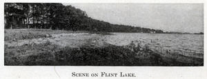
lake lies about three miles nearly north of Valparaiso and about a mile east of
the crest of the moraine. It covers an area of ninety-five acres, and its waters
have an average depth of about forty feet. It is surrounded by high ridges,
those on the north and east being covered with timber. Long lake occupies a
narrow morainic valley a short distance northwest of Flint lake, with which it
is connected by a small drain. The natural outlet of these two lakes is a branch
of Crooked creek, one of the tributaries of the Kankakee river. Long lake is
about three-fourths of a mile in length with a maximum width of some forty rods.
Clear lake is located on the line between Porter and Laporte counties about two
miles north of the line dividing Jackson and Washington townships. It covers an
area of about thirty acres and its waters average about twenty-five feet in
depth, but it has no outlet. All these lakes, as previously stated, lie near the
crest of the moraine and their chief source of water supply is the natural
rainfall, each lake draining a small area of the adjacent
6
country. With the settlement of the country, the cutting away of the timber and
the draining of the land, it is noticed that the water in these lakes is
gradually diminishing, and geologists predict that the time will come when they
will entirely disappear. The waters of Flint lake have receded more than fifty
feet from their former margins. Much of this recession is due to the fact,
however, that the city of Valparaiso draws its water supply from the lake,
nearly a million gallons being taken from it daily.
The drainage system of Porter county is governed almost exclusively by the
topography of the central belt, the watershed separating the great lake basin
from the Mississippi valley corresponding very closely to the summit of the
moraine already described. Except the Calumet and Kankakee rivers, all the
streams of consequence draining the county have their sources on or near the
crest of the divide. All those starting north of the crest line flow into Lake
Michigan either directly or through the Calumet river, while all those rising
south of the crest, with one exception, find their way into the Kankakee river.
That exception is Salt Creek, which rises in Morgan township and flows in a
northwesterly direction, piercing the crest not far from Emmettsburg, its waters
finally reaching the Calumet river in Portage township. South of the divide the
principal streams are Crooked and Sandy Hook creeks. The former has no
tributaries worthy of mention, but the latter receives the waters of Wolf creek,
the west branch of the Sandy Hook, and Cornell creek. All these streams are of
small size and sluggish in their flow. In addition to Salt creek, the principal
stream in the northern part of the county is Coffee creek, which rises near the
crest of the divide in the southern part of Jackson township and flows in a
general northwesterly direction until it empties into the Calumet river at
Chesterton.
Geologists account for the formation of the Calumet or Northern region as
follows: After the formation of the terminal moraine, the glacier slowly receded
toward the northeast, leaving between the great ice wall and the inner slope of
the moraine a low area, which was soon covered with water from the melting
glacier and from rainfall. This
7
body of water, known to geologists as "Lake Chicago," continued to rise until it
overflowed the moraine at the lowest point, which happened to be near the
present city of Chicago, and through the outlet thus formed the waters of the
glacial lake found their way to the Des Plaines river, and ultimately to the
Mississippi. BIatchley says: "The area of this lake was necessarily a variable
one; since the ice dam on the north was all the time slowly receding. However,
the name Lake Chicago is applied to all its stages from the time of the first
opening of the Chicago outlet until its final closing on account of the overflow
of the Great Lakes, finding for itself a new channel through the Niagara river."
With the opening of the Niagara channel and the Great Lakes taking something
like their present form, the waters of Lake Chicago disappeared, leaving a low
tract of land between the terminal moraine and the lake basin. Leverett has
discovered three well defined ridges which mark in part the old shore line of
Lake Chicago at different stages. To these ridges he has given the name of
beaches. The upper or Glenwood beach was thrown up by the first stage of the
lake and is so named because it is well exposed at the town of Glenwood, a few
miles south of Chicago. It enters Indiana at Dyer and continues due east
unbroken for a little more than two miles, where it becomes broken into sand
hills or dunes, which extend to a point about two miles east of Schererville,
where they come to an end.
The middle or Calumet beach, formed at a later stage, enters Indiana about four
miles north of Dyer and extends almost due east for a distance of eight miles.
Here it is joined by Glenwood beach, which makes its reappearance near the
village of Griffith, and side by side they trend northeastward to a point near
the Calumet river about two miles northeast of Crisman, Porter county, where
they terminate abruptly.
Again the waters of the lake receded, and when they again advanced they threw up
the third ridge, known as the lower or Tolleston beach, since it passes through
the Indiana town of that name. It crosses the western boundary of the state a
mile north of the Little Calumet river and from there extends almost due east to
Miller's Station on the Balt-
8
imore & Ohio and Lake Shore railroads. Here it diverges slightly to the
northeast and ends near the northeast corner of Portage township, Porter county.
North of the Calumet river, in Westchester and Pine townships, are two low lying
beaches, thought to be a continuation of the Glenwood and Calumet beaches. In
places they are separated by a narrow marsh lying a short distance north of the
Michigan Central railway. East of Furnessville the southern beach lies mainly
south of the Michigan Central and the northern beach enters Laporte county not
far from the Northern Indiana Penitentiary. Between the beaches thus formed by
the advancing and receding waters of old Lake Chicago, there have been deposited
sand and silt until the Calumet region has been built up to its present state.
The amount of sand thrown up by the waves of Lake Michigan upon the shores of
Lake and Porter counties has been thus computed by Dr. Edmund Andrews: "For 25
miles west of Michigan City the beach maintains an average cross section of
about 6,000 square yards, and its contents are 264,000,000 cubic yards. In this
division the beach is in the form of a lofty belt of sand dunes, about one-third
of a mile wide and in places 160 to 200 feet in height. In the next eight miles
(extending to the Indiana line) the beach spreads out into a broad belt of low
parallel ridges, about two miles in extreme width. This division has a cross
section of about 16,000 square yards, after deducting the sand which was
deposited by Lake Chicago. It contents amounted to 225,280,000 cubic yards." The
sand dunes form the most picturesque and striking feature of the country's
scenery. Sometimes they are great ridges of sand, a mile or more in length, but
more frequently they are found as isolated hills. The highest of these hills is
Mount Tom in Westchester township, the crest of which is about 190 feet above
the waters of Lake Michigan. In the vicinity of Dune Park the ridges are almost
entirely devoid of vegetation. Blatchley says: "Their bared surface, 50 to 100
feet in height, with sand piled just as steeply as it will lie, gleams and
glistens
9
in the sunlight and reflects the summer's heat with unwonted force. Other ridges
and rounded hills, especially those back some stance from the lake, are often
covered with black oak, northern scrub pine, stunted white pine, and many shrubs
and herbs peculiar to a soil of band. The roots of this vegetation form a
network about the sand grains and prevent the leveling of the dunes. In time,
however, a tree is uprooted, or a forest fire burns off the vegetation. The
protecting network of rootlets is destroyed. A bare spot results over which the
winds freely play. A great storm from the north or northwest scoops out a small
bowl-shaped cavity, and, carrying the sand either south of southwest, drops it
over the hillside. The cavity is cut deeper and wider by succeeding storms, and
a great 'blow-out' in time results. Where a few years before stood a high hill
or unbroken ridge now exists a valley, or a cavity in the hillside, acres,
perhaps, in extent, and reaching nearly to the level of the lake. The sands
which once were there now constitute new hills or ridges which have traveled, as
it were, a greater distance inland. In many places the drifting sands have
wholly or partly covered a tall pine or oak tree. Where but partly covered, its
dead (sometimes living) top projects for a few feet above the crest of the hill
or ridge. One may rest in its shade and not realize that he is sheltered by the
upper limbs of a large tree whose trunk and main branches lie far beneath him
embedded in the sands."
The Calumet river, which drains this northern region of the county, has its
source in Laporte county a short distance east of the Porter county line. It is
a slow sluggish stream with low banks, subject to overflow with the melting of
the snows and the usual rainfall of early spring. After crossing the county line
about half a mile north of the morainic belt, it flows almost due west through
Pine and Westchester townships to Dune Park, where it turns slightly to the
southeast and enters Lake county about a mile south of Long Lake. Then,
following a westward course, it crosses the state line about three miles south
of the city of Hammond. From this point it follows a northwesterly course to a
point near Blue Island, Illinois, where it make a sharp curve,
10
flowing first northeast and then southeast, until it again enters the State of
Indiana not far from Hammond. It then flows eastward and finally empties into
Lake Michigan in section 31, township 37, north, range 7, west, less than three
miles from the point where it first enters Lake county. To distinguish the two
parallel streams flowing across Lake county, the one flowing westward is called
the Little Calumet and the northern stream - the one flowing eastward - is
called the Grand Calumet. During the spring freshets, the Calumet marshes become
the temporary home of myriads of waterfowl and a fruitful field for the
sportsman.
That portion of Porter county lying south of the southern border of the
Valparaiso moraine is included in the Kankakee basin. Of this section about
sixty-five square miles consist of swamp land proper and forty square miles of
prairie, which lies from ten to forty feet above the level of the marsh lands.
The Kankakee river, which forms the southern boundary of the county, is noted
for the crookedness of its channel, its low banks and its sluggish current. From
its source in a marsh about three miles southwest of the city of South Bend,
Indiana, to where it crosses the state line at the southwest corner of Lake
county is, in a direct line, about seventy-five miles. Yet, within that distance
the stream is said to make 2,000 bends and to flow a total distance of 240
miles.
The Kankakee marshes constitute the most extensive body of swamp land in the
state. Some of the lands have been reclaimed and brought under cultivation.
Before this was done the area of marsh lands in the seven counties drained by
the Kankakee was estimated at 500,000 acres. As early as 1858 an effort was made
to reclaim some of the marsh lands by the excavation of a large ditch. The
experiment showed that the lands could be drained and a few years later the
legislature of Indiana passed a law under which was organized the "Kankakee
Valley Drainage Association," with power to levy assessments against the lands
to be benefited. In many instances these assessments were opposed upon the
grounds that they were unjust, excessive or partial; indigna-
11
tion meetings were held, and the opposition grew so formidable and determined
that the association passed out of existence without making any serious attempt
to carry out the works for which it was organized. Since then various schemes
have been tried for the purpose of reclaiming the land. In 1870 another large
ditch was dug. This was followed by dredging the tributaries of the Kankakee,
which had a good effect. A mile of rock, seven feet in thickness, was removed
from the river at Momence, Illinois, at the expense of the state of Indiana, and
thousands of dollars have been expended in other directions. No richer soil can
be found in the state. It is a dark, sandy loam, rich in organic matter, and
ranges from three to six feet in depth. Where brought under cultivation good
crops are the universal result. In 1897 Blatchley estimated the amount of
unreclaimed marsh land in Porter county at 40,000 acres, which he says "for at
least four months of the year are covered with from one to five feet of water;
and during the four remaining months this area is an immense bog or quagmire."
Geologically, Porter county is comparatively young. At several points where deep
bores have been driven the bed rock has generally been found to be the black
Genesee shale of the Devonian age. In some places in Lake county it is the lower
Helderberg limestone, and in others it is the Niagara limestone, both of the
Upper Silurian age. Says Blatchley : "Could all the drift be removed from the
surface of Lake and Porter counties the elevations of the different portions of
the exposed surface would be found to vary but little, and the three formations
- Genesee Shale, Lower Helderberg and Niagara limestones - would be exposed as
the surface rock, each occupying its respective area above mentioned. If the
black shale could in turn be stripped from the area which it covers, beneath it
would be found the Lower Helderberg, and beneath that the Niagara."
Consequently there are no fossils of importance to the scientist to he found in
the county, except possibly a few belonging to the Silurian age, and these have
been deposited by the glacial drift. Remains of the mastodon have been found in
the Kankakee marsh three miles southeast
12
of Hebron, near Sandy Hook creek a short distance northwest of Kouts, and in a
marsh on Cobb's creek east of Hebron. In each of these cases a few bones or
teeth were discovered while excavating a drainage ditch, and no systematic
search was made for the rest of the skeleton. The most perfect skeleton ever
found in the county was the one unearthed by some workmen engaged in excavating
what is known as the Koselke ditch in Washington township in the fall of 1911.
On November 4, 1911, a suit was filed by Mrs. Zada Cooper in the Porter Superior
Court, claiming to be "the owner of and lawfully entitled to possession of the
following personal property, to wit: The head, consisting of the skull, upper
and lower jaws, and teeth, fourteen vertebrae, two humeri, two ulnae, two
patellae, twelve ribs, two tusks and other minor bones forming and making a part
of a skeleton of a certain mastodon, a prehistoric animal of immense size," etc.
William Hubbard, Herman Shales and Jacob E. Davis, the men who discovered the
skeleton, were made the defendents, and in her complaint Mrs. Cooper placed a
value of $500 upon the bones, which she claimed had been discovered on a tract
of land owned by her. The case was finally compromised, the plaintiff taking
part of the skeleton, the defendents retaining possession of some of the bones,
and a portion of the skeleton was left in the ground. By a compromise of this
character no one was materially benefited by the discovery. The mastodon
inhabited this country at the close of the glacial period, and the remains found
in Porter county were doubtless left there by one of the great masses of ice,
probably the one which formed the Valparaiso moraine.
With regard to the economic geology of Porter county, it is worthy of note that
it contains but few mineral productions of commercial value. Neither coal,
building stone, oil nor natural gas has been found within its borders. Molding
sand of fine quality occurs at several places, the best known deposits being
near McCool, in Portage township, and near the "Nickel Plate" railway a short
distance southeast of the city of Valparaiso. In the marsh north of Furnessville
and along the Sandy Hook creek in Morgan township there are large peat beds, but
they have
13
never been developed, owing doubtless to the fact that coal can be delivered by
the many railroads so cheaply that it would be unprofitable to work the peat
deposits. Beneath the peat bogs, especially in the Calumet region, there are
great quantities of limonite or bog iron ore. In the peat marsh north of
Furnessville have been found masses of limonite weighing several hundred pounds,
but the ore is too impure to compete with the high grade ores from the Lake
Superior, Missouri and other iron mines. Some years ago a blast furnace was
erected at Mishawaka, St. Joseph county, for the reduction of the bog ores found
in the Kankakee region, but it has long since ceased to exist.
In 1859 Richard Owen made a geological reconnaissance of Indiana, and in his
report says: "On Mr. Howell's elevated land, about three-quarters of a mile
southeast of Valparaiso, on section 30 (35 north, 5 west), we were shown good
gray crystalline limestone which had been quarried and burned into lime; but as
the layer is only two or three feet thick, and apparently local in extent, it
was soon abandoned. Unfortunately, no fossils were found, the lithographic or
lithological character however, indicates a rock of Upper Silurian age."
Subsequent investigation developed the fact that Mr. Howell did burn lime there,
but the stone was not in strata, being set up on edge, the supply proved to be
limited, and the stone was no doubt of the drift origin. In the fall of 1897 it
was reported that an outcrop of sandstone had been discovered on the land of
John Tratebas in the western part of Liberty township in one of the Salt creek
bluffs. Beneath some sixteen feet of soil, clay and sand was a vein of
calcareous sandstone formed by the cementing action of carbonate of lime on the
grains of sand. The blocks of it were rough and irregular in size, and when
exposed showed a tendency to disintegrate into loose sand.
From a commercial standpoint the most important mineral products of the county
are the clay deposits which occur at various places. These clays are sedimentary
in their structure and are divided into two groups - the "drift" clays and the "marly"
clays. The drift clays are made into common brick and into drain tile at Hebron,
Valparaiso and near
14
Chesterton, and the marly clays are manufactured into a fine quality of pressed
front brick at Chesterton, Porter and Garden City. At the last named place there
is an extensive deposit of a fine grained bluish gray clay, which a chemical
analysis shows to be very similar in composition to the celebrated terra cotta
clay used at Glenn's Falls, New Pork. The pressed brick factory at Porter is one
of the largest (if not the largest) in the state. It is owned and operated by
the Chicago Hydraulic Press Brick Company and has been in operation since 1890.
At Chesterton, less than a mile east, the Chicago Brick Company has a large
plant, capable of turning out 35,000 brick daily. There is also a company at
Garden City which manufactures porous fire proof products, the clay being well
adapted to that purpose.
Several artesian or flowing wells have been bored within the county. Near the
northeast corner of Jackson township, just within the borders of the moraine,
Edward Stevens put down a well in June, 1897, which proved to be a flowing well.
The total depth was eighty-four feet, and the water rose through a two-inch pipe
to a height of four feet above the surface with a flow of six gallons per
minute. The Blair well, in the extreme northeastern corner of the county, has a
depth of 840 feet and a flow of eighty gallons per minute. For a time a
sanitarium was maintained here for the treatment of patients, but after the
death of the owner the use of the water for medical purposes has been
practically abandoned. The water contains 690 grains of solids to the gallon,
chiefly chloride of sodium, bicarbonate of calcium, chloride of magnesium,
sulphate of calcium and sulphate of potassium. The Chicago Hydraulic Press Brick
Company bored a deep well at their works at Porter in the hope of obtaining
natural gas. This developed into an artesian well with a flow of about 75
gallons per minute. Dr. J. H. Salisbury of the Northwestern University made an
analysis of the water with the following result:
|
|
Grams per Gal. |
|
Sodium chloride . . . . . . . . . . . . . . . . . . . . . . . . . . . . . . . . |
208.76 |
|
Calcium chloride . . . . . . . . . . . . . . . . . . . . . . . . . . . . . . . |
51.93 |
|
Magnesium chloride . . . . . . . . . . . . . . . . . . . . . . . . . . . . |
38.71 |
15
|
|
Grams per Gal. |
|
Ammonium chloride . . . . . . . . . . . . . . . . . . . . . . . . . . . . |
0.44 |
|
Potassium chloride . . . . . . . . . . . . . . . . . . . . . . . . . . . . |
13.18 |
|
Potassium sulphate . . . . . . . . . . . . . . . . . . . . . . . . . . . . |
17.08 |
|
Calcium carbonate . . . . . . . . . . . . . . . . . . . . . . . . . . . . . |
11.14 |
|
Silica . . . . . . . . . . . . . . . . . . . . . . . . . . . . . . . . . . . . . . . . . |
1.10 |
|
Total solids per gallon . . . . . . . . . . . . . . . . . . . . . . . . . |
342.34 |
Commenting upon his analysis. Dr . Salisbury said: "The water from Porter is
very free from injurious organic matters . It is very useful for drinking at the
well in cases which need alterative or laxative treatment; and it is also useful
for baths and for sanitarium purposes . Its sulphuretted hydrogen will not long
be retained if exposed to the air."
In his report for 1897 Stak Geologist Blatchley publishes a table of altitudes
in Porter county, from which the following are taken, the figures in each case
representing the number of feet above sea level:
|
Chesterton, L. S. Railway . . . . . . . . . . . . . . . . . . . . . . . . . |
670 |
|
Coburg, B. & O. Railway . . . . . . . . . . . . . . . . . . . . . . . . . |
795 |
|
Crest of Moraine, sec. 35, T. 36, R. 6 west . . . . . . . . . |
825 |
|
Crisman, railway crossing . . . . . . . . . . . . . . . . . . . . . . |
645 |
|
Flint Lake (surface of water) . . . . . . . . . . . . . . . . . . . . |
825 |
|
Furnessville . . . . . . . . . . . . . . . . . . . . . . . . . . . . . . . . . . |
670 |
|
Kankakee river (Dunn's bridge) . . . . . . . . . . . . . . . . . |
663.7 |
|
Kouts . . . . . . . . . . . . . . . . . . . . . . . . . . . . . . . . . . . . . . . . |
687 |
|
Morgan Prairie sec. 36, T. 35. R. 5 west . . . . . . . . . |
758 |
|
Summit, near center sec. 30, T. 36, R. 5 west . . . . . |
888 |
|
Valparaiso, Grand Trunk station . . . . . . . . . . . . . . . |
820 |
|
Valparaiso, Court House yard . . . . . . . . . . . . . . . . . |
803 |
|
Wheeler . . . . . . . . . . . . . . . . . . . . . . . . . . . . . . . . . . . . |
665 |
|
Woodville . . . . . . . . . . . . . . . . . . . . . . . . . . . . . . . . . . |
721 |
By comparison of these altitudes with a map of the county one may get a fairly
good idea of the general surface characteristics. The level marked "Summit" in
the table was run by Henry Rankin while surveyor
16
of the county. The point indicated is near the line between Jackson and Liberty
townships, about four and a half miles north of Valparaiso, and is believed to
represent the highest point of land in Porter county.
This chapter may be brought to an appropriate close by a brief mention of the
fauna and flora of the county. Many of the animals that once roamed over this
section of the country are extinct. While the region was inhabited by the
Indians food and fur-bearing animals were plentiful. Notable among these were
the Buffalo, deer, elk, otter and beaver. Smaller animals, some of which are
still to be found, were the gray and fox squirrels, the skunk, the muskrat, the
timber wolf and occasionally a porcupine. Around the lakes and swamps waterfowl
were abundant, especially during their migrating seasons, and the streams teemed
with edible fishes, making a dwelling place well suited to the Red man.
In addition to this the primitive inhabitant found along the sand ridges a
profusion of wild fruits-cranberries, huckleberries, grapes, cherries, plum,
etc. Wild rice grew in the marshes, and nut bearing trees of various kinds were
to be found in the groves. Rev. E. J. Hill of Englewood, Illinois, has made a
special study of the sand dune area, and has found there a number of species of
plants not noted by botanists in other sections of the state. In the Bulletin of
the Chicago Academy of Science in 1891 was published a list of some one hundred
and twenty of these species. Aside from the well known forest trees, this list
included the white, red and dwarf birch, the common pawpaw, wild red, sand and
choke-cherries, several varieties of grapes, violet prairie and bust clover,
asters of different kinds, the golden rod, various species of sumach, and a
large variety of wild flowers. State Geologist Blatchley says: "There is no
better place for an extended botanical study of a limited area in the state than
among the dunes, swamps, peat bogs, prairies and river bottoms of this area, and
it is to be hoped that some one with leisure and ability will, before it is
further modified by man, make a complete and permanent record of its flora."
NAVIGATION OF
1912 HISTORY OF PORTER COUNTY
PREFACE
CONTENTS
CHAPTER I - General Features
CHAPTER II - Aboriginal Inhabitants
CHAPTER III - Settlement and Organization
CHAPTER IV - Internal Improvements
CHAPTER V - Educational Developments
CHAPTER VI - Military History
CHAPTER VII - Township History
CHAPTER VIII - Township History (continued)
CHAPTER IX - The City of Valparaiso
CHAPTER X - Financial and Industrial
CHAPTER XI - The Professions
CHAPTER XII - Societies and Fraternities
CHAPTER XIII - Religious History
CHAPTER XIV - Miscellaneous History
CHAPTER XV - Statistical Review
Transcribed by Steven R. Shook, November 2011